


 When visitors arrive through the gates here at Highclere, I hope they feel as if they are entering a different world for a short time: a few hours of guided tours, delicious food and a wander through the gardens. What is fascinating to me however, is that so many of them have very little idea of where they are, geographically speaking, having simply followed their sat nav to get here.
In fact, in our guidance notes we even suggest a postcode just outside our front gates as some visitors don’t even look out for the brown tourist signs marking the way. They just listen to the staccato voice of the man or woman saying “at the next junction take the fourth exit”.
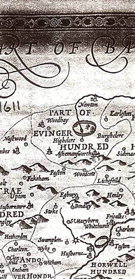
This lack of interest in the detail of the journey is a fairly recent phenomenon. A whole section of the library here is full of maps and, furthermore I have just bought a map chest to help organise those stored in an archive room. I love maps. I find them fascinating and beautiful, showing mankind’s efforts to record the folds, boundaries and natural landmarks of the physical world. They are a pictorial representation of the geography of where each of us live: as the etymology of the word “geography” tells us, it is about writing on the earth.
In addition to the “natural” writing, we can then add the century old boundaries people have drawn marking out their homes, their countries and their tribes. Older boundaries often follow the natural contours within which groups of people may have instinctively gathered but equally they can be rather more arbitrary straighter lines following wars or diplomatic demarcations, for example the Sykes Picot agreement.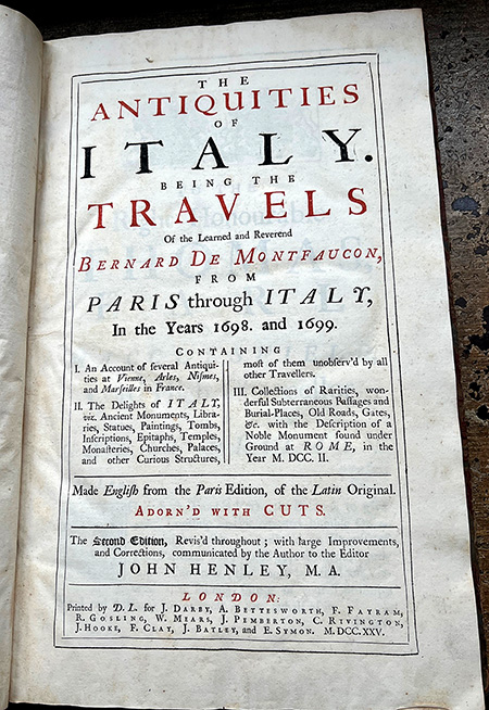
One of the most fundamental questions that humans ask is “when” will something arrive or happen. Children and engineers might also ask “how” something happens but the first question is perhaps more fundamental which is “why”. If you understand the “why”, the “when” or “how” often follow along.
Geography has a remarkable impact on our understanding of all sorts of things and a good map is an essential part of that, helping think about “why”. Open one and look slowly at what it discloses, the steepness of the contour lines, the water resources, the likely climate. It often gives some initial answers as to why people chose to live there, did they move there centuries ago for better agriculture, might it be a place of refuge, is it still a good place to live?
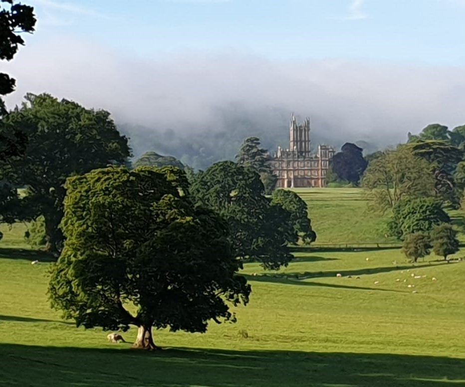
 Sat nav may be useful (although it is not necessarily perfect) but I like to know where I am going. So, you will still find me explaining to visitors that Highclere is 60 miles west of London, that it lies between Winchester and Oxford and on the route northwards from the port of Southampton. This alone is a large part of the explanation of why, some 700 years ago, oaks were felled from Highclere to build both New College Oxford and Winchester College. This, along with the fact that Beacon Hill is such a high spot, also explains why there is an iron age fort here and why it is thankfully relatively easy for visitors to get here today. We are not far from various airports and only 6 miles from Newbury train station.
 If we wish to promote understanding to those currently in education and just being born, it is vital that they know more than just how to tap in a sat nav code or “what three words”. It seems bizarre to me that geography – so integral to much of the understanding of the “why” of our history, is increasingly being seen as a marginal subject by our educationalists.


Wonderful article. As a former tour guide, I perfectly understand the importance of geography and how the environment, the localisation impacted life in the past.
I couldn’t agree more. It’s so important to study geography because it teach us along with history how the world and humanity have come to this point. Why there are so many differents cultures and traditions even in places in the same geoghraplical area and so many other answers to our present situation.
I could not agree with you more! Even in the city in which we currently live, too many people cannot get their bearings when we speak of “turn east” or “it’s 3 blocks north at this corner.” I have long chalked it up to having been raised in a small, rural community. But now, I’m not so sure. I always travel with a printed atlas, but for my most recent purchase, I had to ask 3 associates at the store to help me to locate it and not one of them knew what I was even asking for. They immediately reached for their Smartphones to Google “atlas.” I’m not sure whether to laugh or cry. Thanks to you for preserving so simple a pleasure as knowing where in the world you are!
Dear Lady Carnarvon,
I totally agree with your insight. Maps open our eyes to the world around us, whether close by or far reaching. With the loss of using maps, you have so intelligently noted that one has no idea of the treasures located around the corner. Exploring is a wonderful activity! When my daughter and I traveled in Scotland, a FAVORITE thing to do was just turn down a road to see where it led. We had such fun getting “lost”! In the far north there is little internet service, and I was glad I had my Michelin map in my bag!
Maps offer a window into history, civilization, and human development as individuals and as societies. What a fantastic subject for a Monday morning! As always, thank you! Be well and take good care.
Best regards,
Charlotte Merriam Cole
Thank you
You are so right, thank you for your insite.
Dear Lady Carnarvon,
You are indeed my map friend! Before our trip to England and ending at Highclere in 2013, I looked for maps, maps, maps to show me where we would be going on our bus tour. I love maps, and studying England’s maps was a trip in history. Finding answers to questions such as “Where is Windsor in relation to Highclere?”, and “How far is Bath from London?” while looking at maps was such fun, and my maps still keep me company in my computer memory. Thank you for this tour down the lane to lovely Highclere!
Martha G
How exciting!
I could not agree with you more on your topic today! Oh the joy of opening up a paper map to find my way. You should see the tattered ones in our car door side pocket. It used to be easy to find maps at gas stations. Not any more. Your writings today
bring back wonderful memories of my daddy showing me where were we were going in our travels
in East Africa as a child. And then after we got to our destination, the careful task of folding a map up the proper way. Oh my!! Great topic today Lady Carnarvon.
I agree!
My sweet late mother taught me as a small child how to read a map. I am an only child and my mother said that as we took trips across the United States, my father would drive and she and I were the copilots so we had to know how to read a map. This was before any type of navigation device. How blessed I was in so many ways to have a mother and father like them!!
I was the only grandchild in town, too, so my surviving grandparents played a big role in my childhood. My paternal grandmother always said geography was her favorite subject and after the death of my grandfather, she traveled around the world many times, having amazing adventures. When she would return home, she would regale us with stories of eating snake meat and all sorts of interesting things. I admired her so!!
I hope I imparted some of that love of geography to my children and now my four grandchildren.
Thank you again for an insightful post. I hope to visit Highclere one day in the near future.
I hope to greet you one day!
Good morning! Geography is the most important and interesting of all subjects. It tells us why, why, where, and how civilization developed. Thank you for a most interesting blog piece, this morning.
Best Regards,
Cynthia Hauer
Though we rode on a bus w/ other visitors, I loved your clear explanation of “where” Highclere is located. Being from the US, it is very easy to get lost, turned around, and be very directionally challenged when in another country!
I know how that feels!
I love your posts. Your are such a gifted writer. I’m a librarian and love cartography. I have followed Highclere since Downton. I have been to London several times with dreams of visiting Highclere someday. Thank you for sharing so much educational history of your heritage.
Good Afternoon Lady Carnarvon,
Your Monday missives are always a joy to read and ponder. Today’s is particularly enjoyable as you comment on something that baffles. As society we’re increasingly looking down and/or passively receiving information instead is looking adound, exploring and discovering.
Thank you for sharing your thoughts and lovely surroundings,
Lynne Froehlich
Scottsdale AZ USA
Lady Canarvon, Maps are a part of my husband and my life…always pinpointing boundaries . I am usually the map reader. I hope you and Lord Carvnarvon had a lovely weekend. I happened upon a couple of pictures of your son Edward. I can see both of you in his face. He is a very handsome young man.
I absolutely agree! Can’t comprehend why geography isn’t taught much in school anymore, here in the US. It was one of my favorite subjects (showing my age). At least kids should get on their Google Earth and look up where their homes are. It was fun to see Highclere Castle on it, a bird’s eye view.
Beautiful, archival maps. We enjoy watching, Michael Portillo’s Great British Railway Journeys using a 1913 copy of BRADSHAW’S GUIDE. Does your map collection contain this guidebook or other maps compiled by Cartographer George Bradshaw? Thank you
GEOGRAPHY has been, and possibly still is, the backbone of my life. My father used it during World War 2 in the Tank Corps, I excelled it as a subject at school and later in life
when an officer on passengers ships it literally opened up my world and subsequently my
life in South Africa where married to a former World War 2 air-force navigation officer. Previously I had circled the Globe by bus, train, ship, my own two feet with the aid of maps and ‘chatter’. As you say, geography is becoming a marginal subject which later generations may regret. A simple walk on Hungerford Common is almost a geography lesson itself.
Love this! It’s so important to absorb the history,etc. from each area! Thank you!
Good morning, Lady Carnarvon,
I too love maps and always plot out my route on a map before using my SAT NAV (which can fail or lead me astray).
I just finished your “Catherine…..” book. I enjoyed it very much. I marvel at how you can write such wonderfully researched, entertaining books with all your other responsibilities. Good job!
Sincerely,
Jane Kitchen
Byron Center, Michigan USA
Glad you enjoyed Lady Catherine
Wonderfully put! I live in the United States and it is the same for Americans. They put in the coordinates on their car or phone nav and just go.
I so appreciate your topic this morning. Our snip-its society relying on fast and limited information is only a means to an end. My brother travelled to Australia on a teaching exchange in the late 90’s and he soon earned a reputation for suspicious teaching methods. He believed that reinforcing the book-learning with hands-on experience was beneficial, something that just wasn’t done at the time. From classroom windows the staff would often peek out to see what that crazy Canadian was up to now as the children armed with paper, pencil and enthusiasm explored their terrain in a new way, making maps, identifying plants, bugs, observing the landscapes with connection and comparison. Well informed of possible unwelcome additions to their excursions, he kept the children safe and engaged in their discoveries. I wonder if they still wonder.
I could not agree more, especially with your last sentence ! Maps can tell us so much about where we live, and the local history as well as where we are going. Names on maps are accepted by new residents of country parishes as strange and quaint country names, but look deeper …. for e.g. my daughter lives at ‘The Hoop’ …. odd name …. but it was where the man who made the hoops for cider barrels lived and worked !
Thank you for this beautiful written article and magnificent photos. Geography is so important and young people are being deprived. We always have maps when we go anywhere for a drive. We teach our grandchildren how to read them. They find them fascinating. They also ask why we learned this in school and they haven’t. Wish I could give them an answer,
I also love maps. Every time I open one, I am reminded of my daddy showing me how to read them as a child. Thank you!
Sweet memory
Amen! Great post!
Agree 100% with your Blog this morning Lady Carnarvon and all other comments so far as I too am a fan of historic maps and use of maps (and a fan of your Highclere Map Puzzle!). It is sad these days how Road & other Atlases and individual paper maps aren’t popular topics anymore as Millennials and younger generations these days depend and rely on their mobile phones to get them everywhere and don’t want to deal with books and papers when traveling. Also, sadly the use of paper maps and atlases don’t seem to be teaching topics in education today at youngsters schools and Universities too.
Great article! When I booked my tour with Highclere Castle, your location is the first thing I have checked. I’m visiting from Canada, I’d like to know my bearing.
Sailing helped me how to read maps and be a navigator.
I’m counting the day for the tour and afternoon tea.
I look forward to meeting you
Having navigated many compass courses (U.S. Army) I to have a grounded appreciation and fascination with maps, and am a certified map nerd. It is especially interesting to see maps when our country was in its infancy, and seeing boundaries that remain, and many that are long gone.
Dear Lady Carnavon, I so agree that much of the relevance of our current times lies in the past, our maps, and our verbal, and written history. Much of the enjoyment of travel to a specific destination, to me, is the joy of what we experience along the way. Your newsletters provide a glimpse of how you are working to preserve the history that surrounds you and your family and the maps certainly explain the topography and the evolution of the properties.
Highclere, steeped in history, is one example of using that past to enhance current life, your efforts in restoring the walled gardens have not just piqued my interest but directed me to a path of restoration in my own small way. I now have a copy of Susan Campbells’ “Walled Kitchen Gardens” as inspiration.
Thank you for sharing.
Thank you Lady Carnarvon, An insightful article for sure. I love maps.
My siblings and I were raised reading Ordinance Survey Maps from a young age as our father had surveyed for them before WWII being in the Royal Engineers. This came in useful as we went through leadership in Scouts and Girl Guides as well as Geography at school. Throughout my 50 years of driving , mainly in Canada, I have never been without a map in my car and I always refer to maps before a new journey, be that locally in the Lower Mainland of B.C. or every highway and byway of Kawaii,Hawaii or Palm Springs and surrounding cities. Each time an adventure waiting to happen. It surprises my family and friends that I make myself familiar with routes before travelling but without that knowledge I might miss something of interest which has happened and left me disappointed to have missed. It does sadden me that there is a lack of interest in places often just at their own back door making me so grateful for my childhood in little village in West Yorkshire.
Maps are an integral part of Highclere’s story and each of ours, even today. Students must understand that when family members in generations to come study their story, the geography reveals how and why and often who else. Geography may seem irrelevant to some currently, but it should not be disconnected. It is to be seen as knowing where you are now, where you will be, whete you don’t want to go, and where you and those before you have been.
#Highclere, #familyhistory
Hello Lady Carnarvan,
What a stunning picture of Highclere, with the clouds rolling in from behind the castle. That’s awesome!
Totally with you regarding maps. They tell a story, besides showing the way, and I think are an important part of history. I love reading maps. The Waze app is handy, that’s true, when you are driving and need to pay attention to the road. But looking at an actual map is more interesting!
Have a wonderful week!
Cynthia
I couldn’t agree with you more I don’t have a GPS and have quite a stock of old, and very old, maps of our local area (Shrewsbury). We also have motoring Atlases and would never think of using anything electronic!
Dear Lady Carnarvon,
Technology can be a wonderful thing but sometimes it makes us forget certain things are important. Maps are one of those things. You have reminded us that maps are part of Highclere’s history. I have looked at maps to see where Highclere is and what is around it. Planning for a vacation is part of the fun of traveling. Someday I hope to visit your beautiful home until then I will continue to research and that includes referencing maps. Thank you for reminding us how very important maps are to the understanding of history.
Susan
Thank you Susan
I absolutely loved todays blog. I have always been interested in geography and reading maps of all kinds. As a former teacher I taught and empathized the importance of map reading and had them create their own maps. To this day I still use maps and enjoy studying them. It’s a wonderful past time! I have used maps to locate Highclere and when I do come next year, I will definitely use them.
Pam
As as child I received the Walt Disney World Atlas as a gift. I pored over it endlessly and still have it. People need to understand the what, why and where on everything and understanding geography it vital. Most towns in northern England where I live are located for their proximity to water and unique climate. It ties in completely with history.
Thank you Lady Carnarvon. You have stated what I love about my husband. He too is a collector of maps. He reads them like I read cook books. We have almost as many maps as we have books. That is not quite true because he is a prolific reader with three library stands completely filled with books but maps have a place of honor near the books so they can be easily reached and referenced when he does not know places mentioned. People are always amazed that he can tell them about their small home town far away from our state of Louisiana. We met our dear friends from Darlington years ago on a trip by asking them where in England they were from. They replied that it would be one we never heard of since we are Americans. When told it was Darlington, my husband was able to tell them that he knew of it in Yorkshire and thought it had been a train center. We have been close friends visiting each other across the pond ever since.
I wasn’t aware that geography is not taught in American schools anymore. In fact, at my school, we open the school year with a review of basic map skills. Since the focus of our Social Studies is ancient civilization, it is important that students know of locations of these ancient places. For example, when we study Egypt, the phrase “The Gift of the Nile” makes no sense unless you know the location of the Nile River and its importance to the Egyptian culture, both then and now Yes, I use and like GPS as my county contains many cities and over 1.9 million residents. However, I also know “the lay of the land” where I live.
My husband is the best navigator for planning our road trips here in USA
He uses the DeLorme atlas and Gazetteers. He has one for every state we travel through. He reviews and studies the route over and over. They are excellent road maps.
Lady Carnarvon, thank you for your delightful article about maps and geography. I too am a fan of both and learned at an early age to navigate with a multifolded map while on vacations. I often sit with an atlas and spend happy hours studying the maps of various parts of the world. Those that I have visited come brilliantly to mind as I retrace my travels. Those that are unknown to me challenge me to wonder about topography, climate, history and how these all have affected the course of the routes linking cities over time. My mother’s first cousin once lived in Newbury and when we visited in 1971 we were taken to see Winchester Cathedral. He, Ronald Ballentine, was the co-pilot of the plane which flew Princess/Queen Elizabeth home from Kenya when her father died. Sadly no one mentioned that Highclere was close at hand! I thoroughly enjoy your postings and sincerely hope to visit your lovely home in person one day.
Rev. David A. Eichelberger
Dear Lady Carnarvon
I couldn’t agree more with you on this topic. I really love geography and when I am going on vacation I do want to know where I am going. And in which area I am, and what to visit there. So yes your blog today was awesome.
Els
My dad taught me how to read a map and I’m one of those people that tend to irritate some because I know my north from my south and my east from my west and follow/give directions accordingly. I love a good atlas (my mom does too – she bought one recently to follow a trip my husband and I took from San Diego to Salt Lake City). We spent many a day pouring over maps when we were kids/driving – note an obscure city and the partner would have to find it on the map. Passed many an hour travelling in the backseat that way – always made it a point to play with the person who didn’t get carsick though! 😉
How funny!
I too love maps, thanks to my dear Daddy. I could not agree more with all the insights and wisdom about maps and geography displayed in the comments left by the readers of today’s blog. Thank you, Lady Carnarvon, for opening the door to such an interesting, heartfelt discussion. And I do love that photo of the approach to Highclere with the Castle reflected in the glossy hood of a classic car!
Lady Carnarvon likes get your email thank you very much for send it to me and lovely to picture of coordinates did you and lord Carnarvon have a nice weekend and lovely to visit highcelere castle and l am fan of Downton Abbey
Dear Lady Carnarvon,
Another insightful piece. It provides information and encourages contemplation. I too and I lover of old maps and have collected more than I routinely look at. I like the sense of evolution you can get by moving through the years via maps. It would be fun to browse through the newly organized maps at Highclere. I did follow the GPS to Highclere as well as the signs. Our first visit however was not enough time to take in the delights you see daily. On our next trip my plan is to take the day and do some longer walks.
Thanks for continuing to inspire me.
A great blog today, thank you. I, too, am a map lover and still have most of the maps that I acquired while traveling. One of the first things I did years ago when Highclere became known to me was find it on an old Michelin map of Great Britain (#404!) in order to see where it was in relation to where I had been. That map was acquired over 20 years ago when I spent a week in Winchester singing Evensong in the cathedral with our choir. I have been near to Highclere so many times and still yearn to visit.
Paper maps are hard to come by today and I am afraid the younger generations will lose the fun, insights, facts of history and skills that map reading can and does offer. They really are important to us for learning all kinds of things. Thank you for reminding us all about maps.
Thank you
Looking forward to visiting in April
I love this – I am fascinated by maps and always travel with one (I don’t trust Sat Navs!!) My favourite maps are the Ordnance Survey maps that show contours so you can see the lay of the land better.
I love ordinance survey maps!
Dear Lady Carnarvon,
Loved your article. Those were the good times, looking over a map trying to figure out which way to go an always getting there. People need to know how to read maps these days not just following a computer app.
Thank you,
Carolyn
I love paper maps. I want to understand the relationship of where I may be with what is around me and perhaps find something else of interest nearby. Thank you for sharing my love of maps.
Thank you once again Lady Carnarvon for a thoughtful, elegant essay. I can assure you and your readers that Geography and map reading were always taught in my US third/fourth grade classroom. How can we know where we want to go if we don’t know where we are? Ironically, the students who struggled with reading text, were often the best at reading maps. I will always be a champion for a rigorous,balanced curriculum.
Cheers to you, and keep the inspiration coming !
Carol Singh
Thank you for your entry today on geography and maps. I love both and at one time hoped to major in geography in college. Both intertwine history and the land. My reading place in your book, The Earl and the Pharaoh, is just before King Tut is discovered. Howard Carter and The Earl’s maps and descriptions have been valuable throughout history. It’s so exciting to get to know the how, why, what, and where of that land through time. From the hot air balloon over the Valleys of the Kings and Queens one can survey the terrain and appreciate the monumental task of excavation.
Thoroughly enjoyed Coordinates!
Dear Lady Carnarvon:
Thank you for your Monday blog and for sharing your perspective on Cartography and Geography. As usual, you have several great photographs. My favorite is the flat “butterflied” map.
When in school, I truly enjoyed my Geography classes. This is where I had learned to draw, highlight, and read a map. Now I believe the subject of Geography is incorporated into the curriculum of American History, Civics, Principles, Economics, and World History. It is generally taught between Middle and High School, and unfortunately, it is considered more of an elective than a required course. It appears that students today are more interested in looking down at their hand-held device, than looking ahead and going out to explore and investigate on their own.
I must admit that I am guilty of relying on Alexa or Siri for pre-requested and loaded audio directions. Reading a map and attempting to drive at the same time is quite a challenge, distraction, and not really safe to do anyway.
So, until next week, keep organizing and archiving your maps.
Perpetua Crawford
The maps here are amazing
Dear Lady Carnarvon,
As a child growing up, I loved maps. When my father took us road trips in the car I would be the one with the paper map in my lap, following the route we were taking on the map. I loved seeing cities/towns on the map and then experiencing us driving through them. Still to this day, I love a paper map.
When my friend and I travelled to London, England from Canada (with our main mission being a visit to Highclere), we took the train from London to Newbury. We loved the adventure and the scenery. We really enjoyed Highclere and the grounds. It was the highlight of our trip to the U.K..
Thank you for sharing your home as well as your thoughts regarding maps.
Thank you !
When we visited the UK from the US prior to the pandemic, we included Highclere on our visit. We elected to use a bus/tour company for transport. I studied the map to Highclere and the transportation options. As much as possible, we avoid car rental/hire. So we opted for the bus tour as it seemed to be the most convenient & least stressful.
I too love maps, Lady Carnarvon. Purchased a car new in 2017 and I just learned to use the Nav a couple of months ago. Remembering my mother and father unfolding and looking at maps during our cross-country trips in the US brings back warm memories.
You remind me of the book GEOGRAPHY TO NOWHERE detailed in my THE NEW WAVE writing. It is specific to America but it can generalized to the Western culture with its summary: “America’s evolution from a nation of Main Streets and coherent communities to a land where every place is like no place in particular, where the cities are dead zones and the countryside is a wasteland of cartoon architecture and parking lots. A call for citizens to reinvent the places where we live and work, to build communities that are once again worthy of our affection. By reviving civic art and civic life, we will rediscover public virtue and a new vision of the common good.” Life is a reflection of cultural way life in the West with no substantive connection to the past, nowhere present and “future” daydreaming in a decadent lifestyle. Landmarks are simply shadows of a long ago way of life to be sold for trinkets. One can call it one-dimensional thinking but it reflects the western culture with everything being commodified without meaning except profit. Good luck. JC
I agree entirely. I’m amazed at how many people have no idea where things lay in relation to each other. Friends from Manhattan coming west to our place in NJ are often clueless and rely too often on sat nav, and can’t even read the map provided by sat nav on their cars dashboard. As a Boy Scout, we learned how to read maps as a matter of potential survival skills when hiking or camping in the wilderness, which NJ had in my youth!
I’m fascinated with maps, particularly old maps overlaid upon new maps, to see how the urban sprawl has changed the landscape, and finding roads and little villages which no longer exist. I am a landscape designer and horticulturist, so survey maps showing topography are particularly appealing. Speaking of the landscape, I love the first photo in this post, which seems to show a ha-ha, a brilliant landscape design concept which I hope you feature in a future blog post. Just a gentle nudge, as it would be a learning experience for people who are lacking geography/topography knowledge.
As usual, thank you once again for a lovely Monday email!
Great article. You are so right. We need to know all about our history. Thanks.
Lady Carnarvon:
Me encanta este tema de los mapas ,distancias !! Cuanto se aprende . Acompañado de la historia y desarrollo !! Cuanta vida!!
Gracias.
I agree with you 100% regarding the study of geography, but also of history. I feel as a society we are making a great mistake in not teaching these subjects to our children. The world today demands critical thinking and historical knowledge to solve the problems that confront us. Knowledge is power.
There was a TV show in the US a few years ago–can’t remember the name or overall plot–that involved a group of young employees and a man 20 or so years older as the manager. I saw just a few snippets here and there, but the one that has stuck with me involved the manager coming in with a map partly unfolded in his hand. One of the young girls saw it and called out, “Look! He’s got a GPS on paper!” I still chuckle every time I think of it. We try to make sure we have real maps with us whenever we travel, and I was happy to see that one of my sons was teaching his then 4-year-old to read a map. Thank you for a lovely piece, which has clearly struck a nerve with many of us.